EVACUATION ROUTE
Municipality of Loiza, Puerto Rico
Overview
Due to its geographical location, Puerto Rico is highly exposed to extreme natural events such as weather events (e.g., hurricanes) or earthquakes. The exposure to extreme natural events affects the transportation infrastructure. Damages to the transportation results in the isolation of communities limiting their ability to obtain supplies and services in an efficient and timely manner in the recovery phase after the extreme natural event. This has been proven by recent extreme events occurred in Puerto Rico. Consequently, the PR 2045 Long Range Transportation Plan (2045 LRTP) established the resiliency during transportation planning as one of the strategies to enhancing the quality of life through management of assets, environmental and social justice, improved accessibility, and better economic development.
The town of Loíza is in an area with privileged natural environmental characteristics. These characteristics make it vulnerable to natural disasters or incidents that would require the evacuation of the town during emergencies. According to 2020 Census the municipality has a population of 23,693. According to the Census criteria the municipality is not an urban area composed mostly of Latino (99.7 %) dominated by the black (38.7 %) and white (24.3 %) races. Poverty percent is estimated in 48.2 %. The town is in an Area of Persistent Poverty (APP) and is a Historically Disadvantaged Community (HDC).
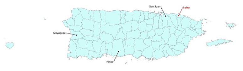 Location of Loíza in Puerto Rico Main Island.
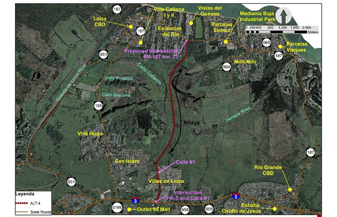
Loíza limits to the north with the Atlantic Ocean, to the south with the municipality of Canóvanas, to the east with municipality Río Grande and to the west with the municipality of Carolina. The municipality has six (6) wards: Torrecillas Baja, Torrecillas Alta, Canóvanas, Medianía Baja, Medianía Alta and Pueblo. The municipality has an area of approximately 19.4 square miles and the terrain is mostly flat and does not exceed 100 meters (328 feet) above sea level. Private vehicles are the principal mode of transportation in the municipality. The current main access to Loíza is along State Roads PR-188 and PR-187. The following figure shows the limits of Loíza and principal roads within the municipality.
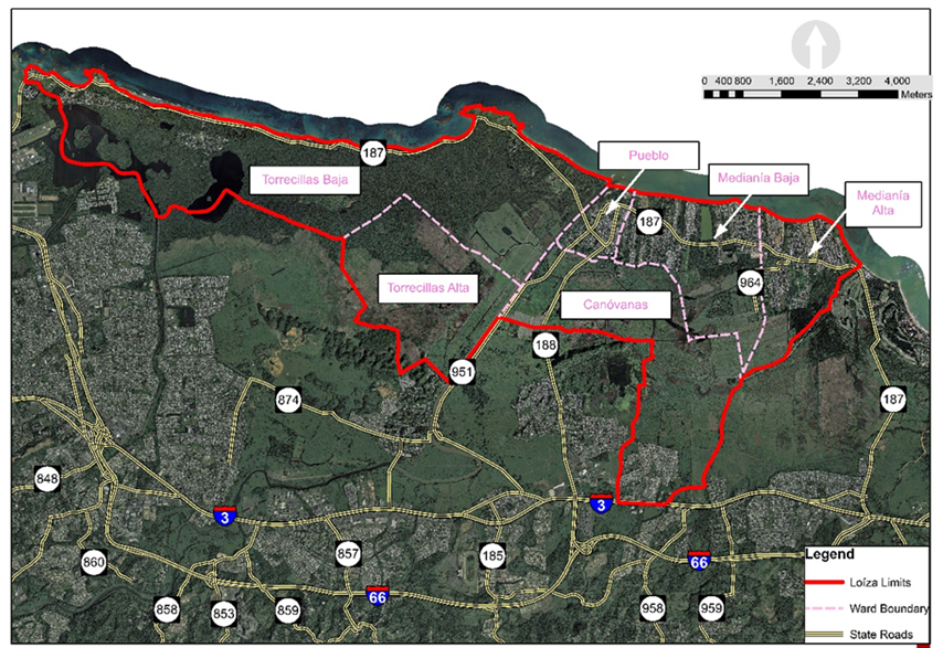
Loíza Limits and principal roads in an Aerial Photo
There is a government evacuation plan for Loíza town in the event of a disaster. Currently the evacuation routes are through States Roads PR-188 and PR-187. See the following figures.
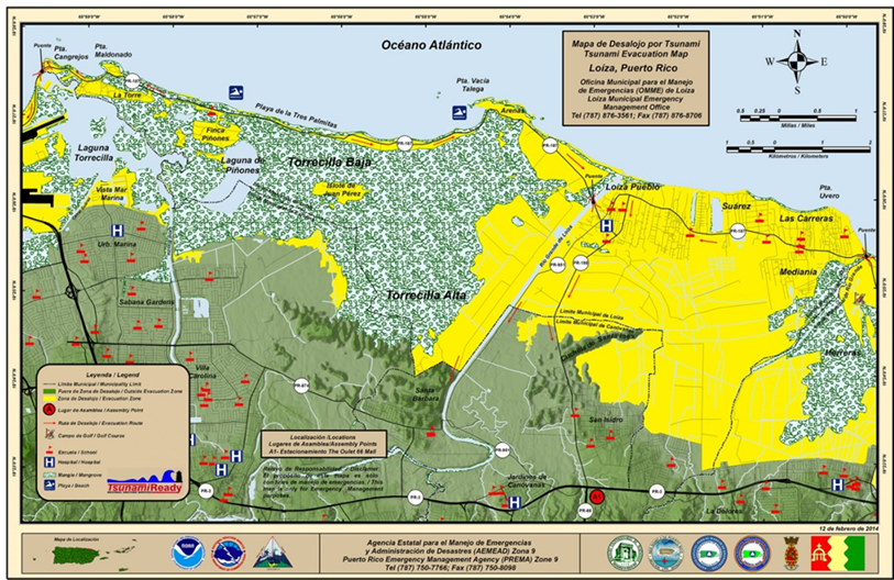 Map of the evacuation zone during a Tsunami.
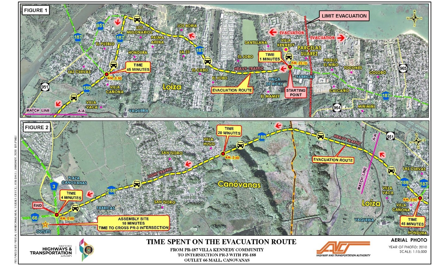 Diagram of evacuation process experience during January 7, 2020, earthquake.
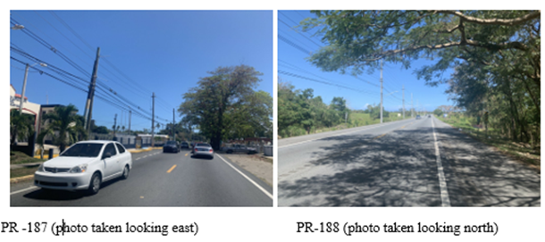
The PR-188 is mostly a two-lane secondary road that runs from PR-3 and ends at PR-187 south of the town area of the municipality of Loíza. The PR-187 is a secondary two-lane highway that begins at PR-26 and ends at PR-3. The path of the highway is from east to west and runs through the town area of the municipality. The assembly places, for those who evacuate via PR-188, is the parking lot of The Outlet 66 Mall. For those who evacuate via PR-187, it is the Ovidio de Jesús baseball field, in the municipality of Río Grande.
 Project Description
The Puerto Rico Department of Transportation and Public Works through the Puerto Rico Highway and Transportation Authority propose the development of a new road infrastructure that would be used as an evacuation route during emergencies events for residents and visitors of the town area of the Municipality of Loíza, Puerto Rico.
Currently the PRHTA in coordination with the Federal Highway Administration (FHWA) is preparing the Feasibility Study. The preliminary feasibility study was performed using information on the resources and characteristics of the study area available from government agencies, information obtained from the public, studies performed, and information obtained during field visits. Four alternatives, including the No Action alternative, are begin evaluated. From these, three alternatives have been preliminary determined to be feasible as an evacuation route. These are the No Action alternative and the construction of a new transportation infrastructure in three different alignments. Summary of these alternatives are included below.
- Alternative #1 (No Action) – The no action alternative consists in maintaining the existing transportation infrastructure without significant changes. Existing evacuation routes would be used; improvements in pavement marking and signalization would be performed in existing evacuation routes (PR-188 and PR-187) to guide drivers.
- Alternative #2 (Improvements to the Existing Road System and Construction of South Connector) – This alternative includes: (1) Build the South Connector (new road) from PR-187 km. 21 to PR-188 km. 5.3; and (2) Perform improvements to State Road PR-188 along its existing alignment, from the intersection of PR-187 with PR-188 (km 5.85) to the intersection of PR-3 with PR-188. Estimate construction cost of this alternative is $93 million. This alternative can be constructed in three phases.
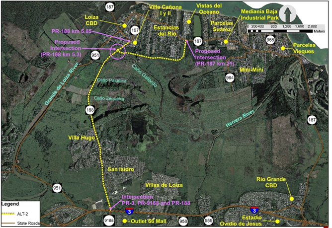
Evacuation Route Alternative #2 Alignment.
- Alternative #3 (Improvements to the Existing Road System and Construction of South and Villas de Loíza Connectors) – This alternative includes: (1) Build the South Connector (new road) from PR-187 km. 21 to PR-188 km. 5.3; (2) Perform improvements to State Road PR-188 between kilometers 2.6 and 5.85.; and (3) The construction of Villas de Loíza Connector (new road) between PR-188 km. 2.6 and Calle #1 of the Villas de Loíza urbanization. Estimate construction cost of this alternative is $145 million. This alternative can be constructed in three phases.
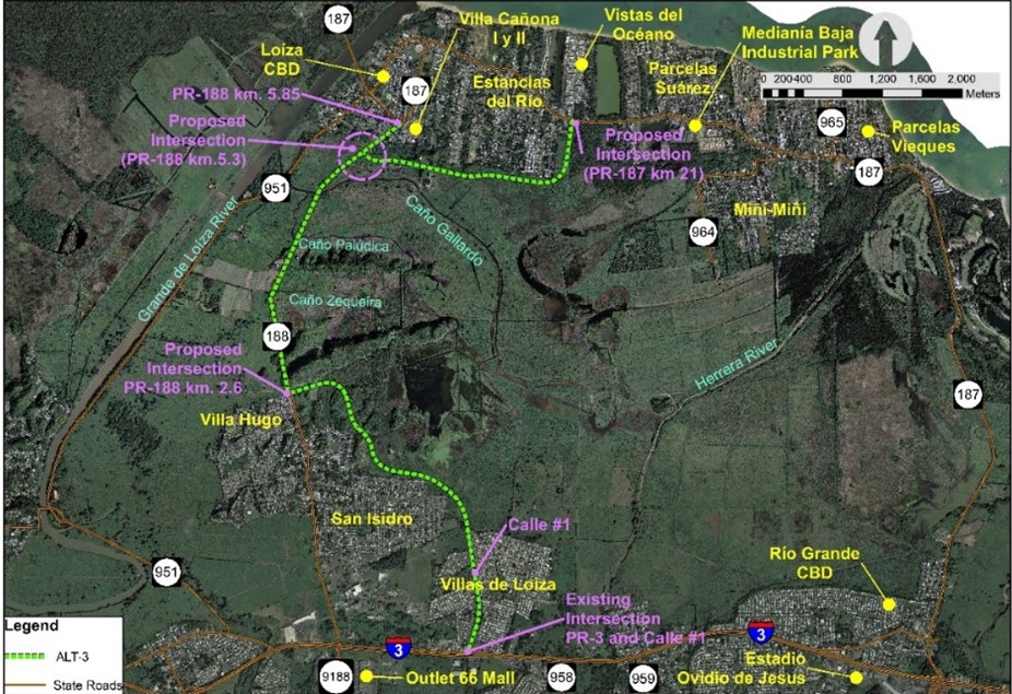 Evacuation Route Alternative #3 Alignment.
- Alternative #4 (Construction of New Road-Bridge) – This alternative includes: (1) Build a new road (including a bridge of 2.87 km) from PR-187 km. 21 to Calle #1 of the Villas de Loíza urbanization. Estimate construction cost of this alternative is $354 million. This alternative would be constructed in one phase.
Evacuation Route Alternative #4 Alignment.
For all the alternatives the road profile would be above the flood levels. The typical road section of road PR-188, Villas de Loíza Connector and Alternative #4 would have three lanes (two north-south and one south-north). During an emergency event the southbound lanes would be used to evacuate the town, and the northbound lane would be used by government agencies to provide assistance to the population. The typical section of the South Connector would have two lanes (one in each direction).
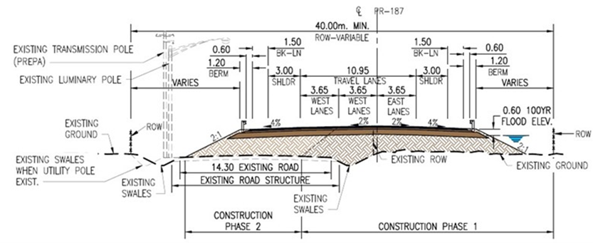 State Road PR-188 and Villas de Loíza South Connector
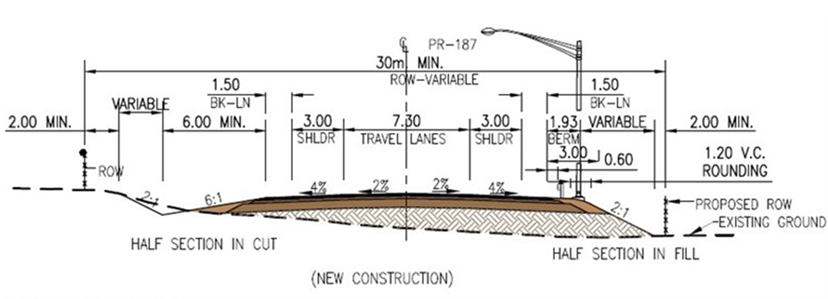
Loíza South Connector
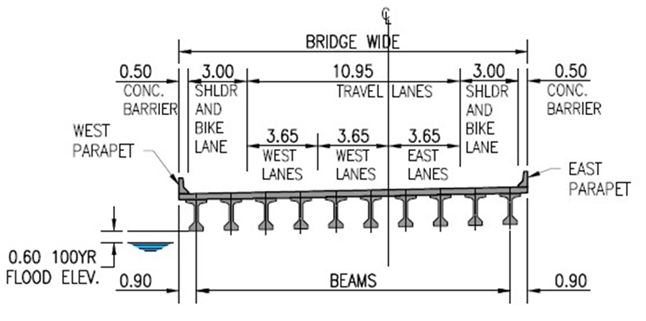 Improvements to PR-188 Bridges and Alternative #4 Bridge
Funding
The PRHTA is currently preparing the Feasibility Study and funds for this phase of the project have been allocated. The Feasibility Study is being financed by the FHWA. The PRHTA estimates that the project planning phase (environmental evaluation and preparation of design) will cost $12,372,393. The planning. Phase is submitted to the US Department of Transportation to compete for RAISE funds. Here is a copy of the request.
Appendix 1 – Photos taken Post Hurricane María (September 2017)
Appendix 2 –Video of January 7, 2020, Earthquake Evacuation Process
Appendix 3 – Documents that illustrate the Community claim for the Evacuation Route
Appendix 4 – Opinion of Probable Environmental Evaluation and Design Cost
Appendix 5 – Project Supporting Letters
Appendix 6 – PRHTA Public Involvement Plan for the Environmental Process